 HKA Texas Humble, Kingwood, Atascocita, Texas Humble, Kingwood, Atascocita, Texas

For the last several weeks, the Montgomery County and Greater Houston areas have been in an extraordinarily wet weather pattern that has generated numerous, intense storm events causing widespread flooding. This morning, the Lake Conroe area received another two to four inches of rainfall, resulting in a lake level rise of over a foot. Over the past 48 hours, the watershed has received between three and six inches of rainfall.
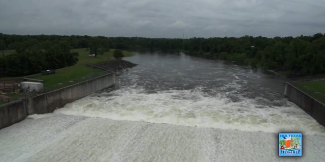
As of 4:00 PM today, Lake Conroe is 18 inches over its “full” level of 201’ above mean sea level, and the San Jacinto River Authority (SJRA) is currently releasing water from the dam at a rate of 8,660 cubic feet per second. The graph below shows the Lake Conroe level over the past 30 days. The lake level appears to be holding at approximately 202.5’ MSL, but water will continue to drain out of the watershed for the next several days.

Based on the combination of saturated ground conditions, high inflows into the reservoir, and the current forecast and lake level, it is likely that this rate of release will continue through the night.
SJRA is working within their operational protocol to buffer releases to the extent they can. “Safety is always our first concern – both the safety of the structure and the safety of residents upstream and downstream of the dam.” says SJRA. Even though Lake Conroe is not designed as a flood control reservoir, it does buffer downstream impacts by holding some water behind the dam and releasing this water slowly over time.
Anyone living in low-lying or poorly-draining areas is encouraged to monitor local conditions and take any necessary precautions.
There are a number of separate drainage basins (or watersheds) that contribute flow into the San Jacinto River. Residents should monitor stream conditions in their area to determine if evacuation is necessary. See the map below for a map of local drainage basins.

SJRA provides continuous data regarding lake level and release rate on its homepage at www.sjra.net. In addition, historic data can be accessed by clicking the link labeled “Additional Data” (look for the map labeled San Jacinto Contrail Web).
SJRA personnel are currently conducting 24-hour operations and will continue to monitor the forecast and the rate of continued lake level rise to determine if and when additional increases in the release rate may be required.